- A+
所属分类:Web前端
这里给大家分享我在网上总结出来的一些知识,希望对大家有所帮助
不想看繁琐步骤的,可以直接去github下载项目,如果可以顺便来个star哈哈
本项目使用vue-cli创建,但不影响使用,主要绘制都已封装成类
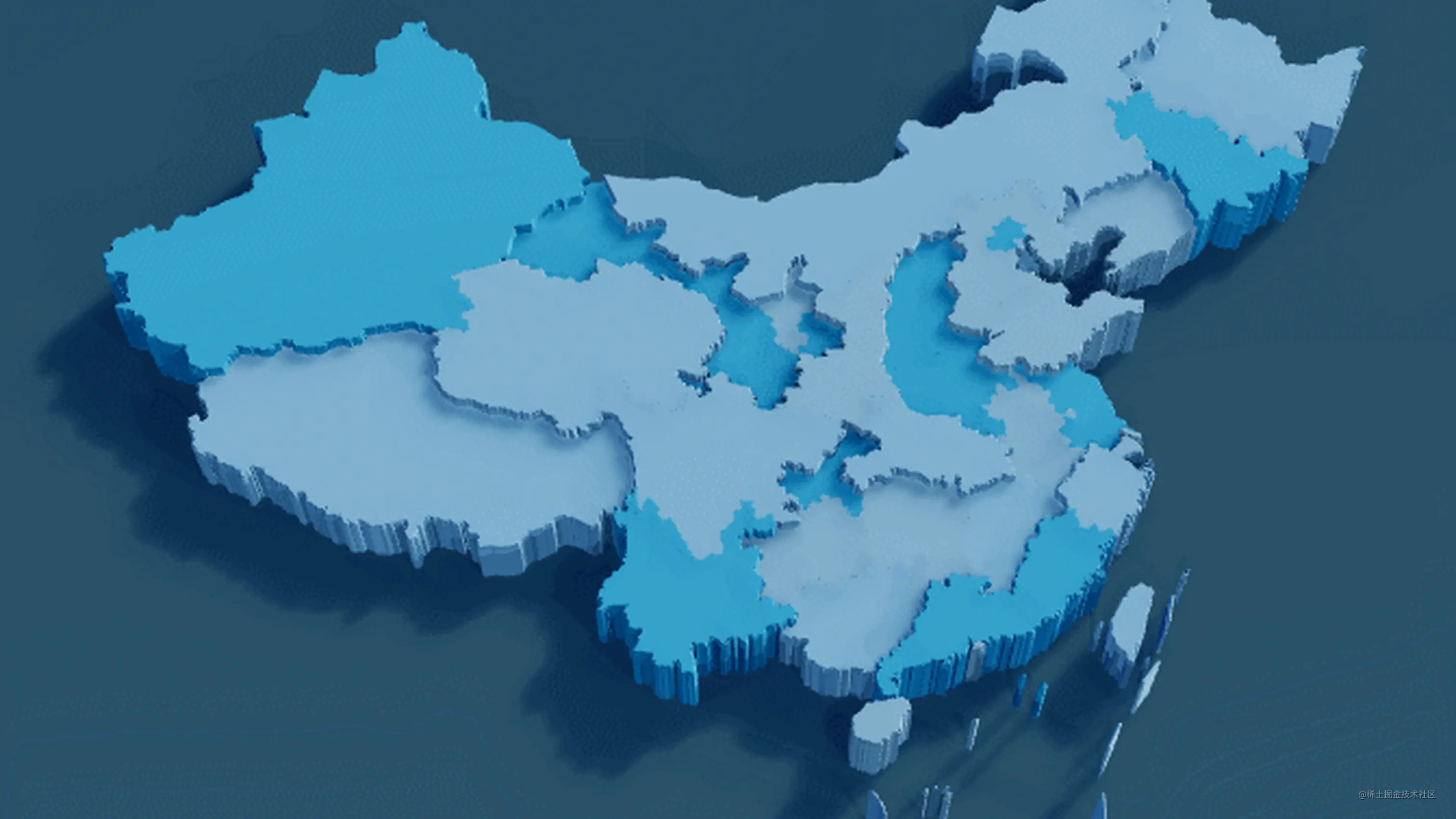
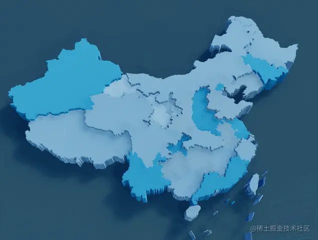
1、使用geoJson绘制3d地图
1.1 创建场景相关
// 创建webGL渲染器 this.renderer = new THREE.WebGLRenderer( { antialias: true,alpha: true} ); this.renderer.shadowMap.enabled = true; // 开启阴影 this.renderer.shadowMap.type = THREE.PCFSoftShadowMap; this.renderer.toneMapping = THREE.ACESFilmicToneMapping; this.renderer.toneMappingExposure = 1.25; // 根据自己的需要调整颜色模式 // this.renderer.outputEncoding = THREE.sRGBEncoding; this.renderer.outputEncoding = THREE.sHSVEncoding; this.renderer.setPixelRatio( window.devicePixelRatio ); // 清除背景色,透明背景 this.renderer.setClearColor(0xffffff, 0); this.renderer.setSize(this.width, this.height); // 场景 this.scene = new THREE.Scene(); this.scene.background = null // 相机 透视相机 this.camera = new THREE.PerspectiveCamera(45, this.width / this.height, 0.1, 5000); this.camera.position.set(0, -40, 70); this.camera.lookAt(0, 0, 0);
1.2 根据json绘制地图
利用THREE.Shape绘制地图的平面边数据,再用THREE.ExtrudeGeometry将一个面拉高成3d模型,3d饼图同理也可以这么制作
let jsonData = require('./json/china.json') this.initMap(jsonData); // initMap 方法主要部分 initMap(chinaJson) { /* ...省略 ... */ chinaJson.features.forEach((elem, index) => { // 定一个省份3D对象 const province = new THREE.Object3D(); // 每个的 坐标 数组 const { coordinates } = elem.geometry; const color = COLOR_ARR[index % COLOR_ARR.length] // 循环坐标数组 coordinates.forEach(multiPolygon => { multiPolygon.forEach((polygon) => { const shape = new THREE.Shape(); for (let i = 0; i < polygon.length; i++) { let [x, y] = projection(polygon[i]); if (i === 0) { shape.moveTo(x, -y); } shape.lineTo(x, -y); } const extrudeSettings = { depth: 4, bevelEnabled: true, bevelSegments: 1, bevelThickness: 0.2 }; const geometry = new THREE.ExtrudeGeometry(shape, extrudeSettings); // 平面部分材质 const material = new THREE.MeshStandardMaterial( { metalness: 1, color: color, } ); // 拉高部分材质 const material1 = new THREE.MeshStandardMaterial( { metalness: 1, roughness: 1, color: color, } ); const mesh = new THREE.Mesh(geometry, [ material, material1 ]); // 设置高度将省区分开来 if (index % 2 === 0) { mesh.scale.set(1, 1, 1.2); } // 给mesh开启阴影 mesh.castShadow = true mesh.receiveShadow = true mesh._color = color province.add(mesh); }) }) _this.map.add(province); }) }
geoJson的坐标需要进行墨卡托投影转换才能转换成平面坐标,这里需要用到d3
// 墨卡托投影转换 const projection = d3.geoMercator().center([104.0, 37.5]).scale(80).translate([0, 0]);
2、增加光照
我们把各种光都打上,环境光,半球光,点光,平行光。以平行光为例,增加投影,调整投影分辨率,避免投影出现马赛克
const light = new THREE.DirectionalLight( 0xffffff, 0.5 ); light.position.set( 20, -50, 20 ); light.castShadow = true; light.shadow.mapSize.width = 1024; light.shadow.mapSize.height = 1024; this.scene.add(light);
castShadow = true表示开启投影
3、增加阴影模糊
默认的阴影没有模糊效果,看起来像白炽灯照射的样子,没有柔和感。使用官方示例中的csm来增加阴影模糊
import { CSM } from 'three/examples/jsm/csm/CSM.js'; this.csm = new CSM( { maxFar: params.far, cascades: 4, mode: params.mode, parent: this.scene, shadowMapSize: 1024, lightDirection: new THREE.Vector3( params.lightX, params.lightY, params.lightZ ).normalize(), camera: this.camera } );
4、增加鼠标事件
在3d空间中,鼠标事件主要通过射线来获取鼠标所在位置,可以想象成鼠标放出一道射线,照射到的第一个物体就是鼠标所在位置。此时用的threejs的Raycaster,通过Raycaster给对应的省份增加鼠标移入高亮效果和省份民悬浮展示效果
this.raycaster = new THREE.Raycaster(); // 传入需要检测的对象 group,group下的所有对象都会被检测到,如果被射线照到,则intersects有值,表示鼠标当前在这些物体上 const intersects = this.raycaster.intersectObject( this.group, true ); // 代码太多就不贴了,见 GitHub源码
5、渲染
threejs的渲染一般调用原生的requestAnimationFrame,主要做的事就是调用renderer的render方法,当然因为我们做了阴影模糊处理,所以还有别的需要做的:
this.camera.updateMatrixWorld(); this.csm.update(); this.renderer.render(this.scene, this.camera);
6、动画效果
地图上如果有一些动画效果,可以使用TWEEN.js,github地址,比如地图标注的出现动画:
最后再奉上项目地址
本文转载于:
https://juejin.cn/post/7057808453263163422
如果对您有所帮助,欢迎您点个关注,我会定时更新技术文档,大家一起讨论学习,一起进步。