- A+
所属分类:Web前端
2023-01-04
最近想用Cesium给学校做一个类似智慧校园的东西,要做的东西很多,首先是获取学校模型的问题,然后怎么用Cesium加载3Dtile
1.获取学校模型
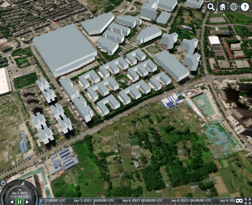
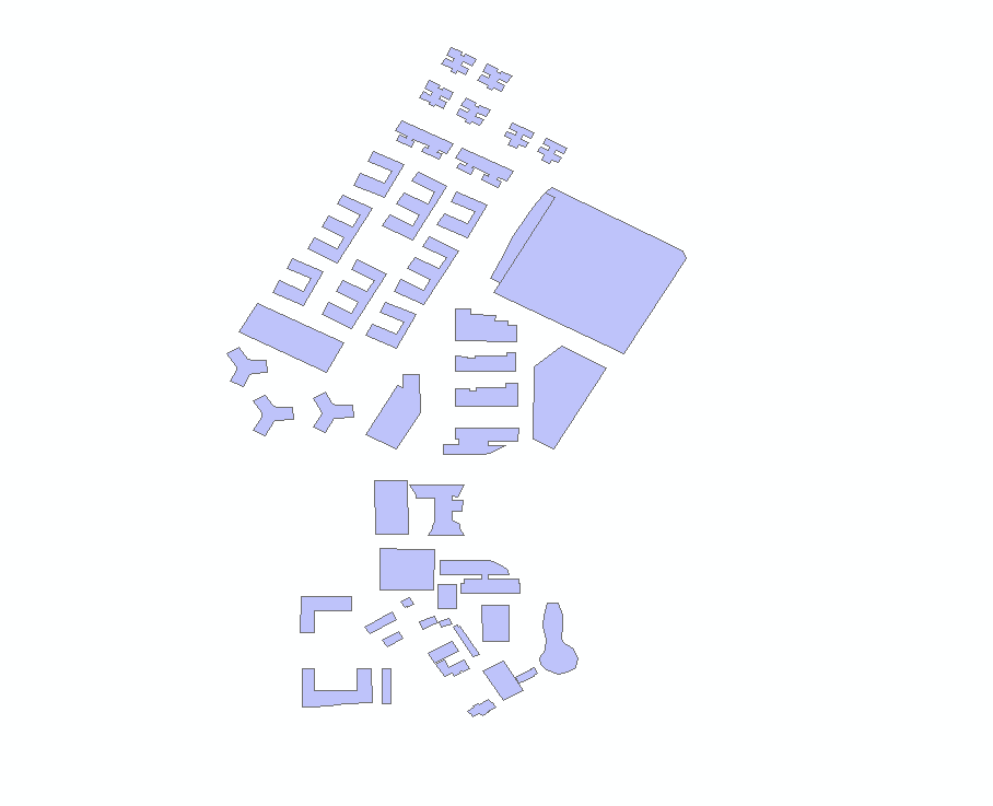
想到之前被老师抓苦力去做春熙路的图,于是决定用比较熟悉的OSM数据集
https://www.openstreetmap.org/ 需要梯子
进入后很容易就可以下载到所需区域的矢量数据
后续选择用ArcMap处理数据,但下载的OSM需要一个插件才能用ArcMap打开
https://github.com/Esri/arcgis-osm-editor
选择对应版本就可以了
在ArcMap里清洗并加上高度属性就可以了,大概是这个样子
如何变成3dtile格式呢,搜索了一下发现用CesiumLab最方便
下载过后会在浏览器打开一个窗口
如果要将shp文件转换为3dtile,里面有文档跟着操作就可以了,上图那种数据量一秒就转换好了
2.Cesium加载3dtile
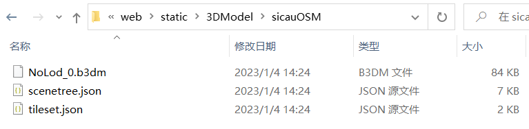
我是在vue里用的cesium,直接将刚才生成的3dtile放在static下
加载3dtile代码如下:
var tileset = new Cesium.Cesium3DTileset({ url: "../../../static/3DModel/sicauOSM/tileset.json", }); viewer.scene.primitives.add(tileset); console.log(tileset);
因为生成模型时候的问题,导致模型在地底下去了,调整模型位置代码如下:
//3dtile加载完成后执行 tileset.readyPromise.then(function(tileset) { //高度偏差,向上是正数,向下是负数 var heightOffset = 500.0; //计算tileset的绑定范围 var boundingSphere = tileset.boundingSphere; //计算中心点位置 /** * fromCartesian 方法是用经纬度和高度定义一个位置 * A position defined by longitude, latitude, and height. */ var cartographic = Cesium.Cartographic.fromCartesian(boundingSphere.center); //计算中心点位置的地表坐标 /** * Cartesian3 是一个3D点 * fromRadians 方法 Returns a Cartesian3 position from longitude and latitude values given in radians(弧度). * @param longitude * @param latitude * @param height * 因为建筑模型没他所在高度信息,所以填0 */ var surface = Cesium.Cartesian3.fromRadians(cartographic.longitude, cartographic.latitude, 0.0); //偏移后的坐标,也就是中心点本应在的高度(海拔) var offset = Cesium.Cartesian3.fromRadians(cartographic.longitude, cartographic.latitude, heightOffset); /** * subtract 方法 Computes the componentwise difference of two Cartesians. * 计算两个笛卡尔坐标的成分差异 * @param 就是两个要计算的坐标 * @param 第三个参数是要保存的结果 */ var translation = Cesium.Cartesian3.subtract(offset, surface, new Cesium.Cartesian3()); console.log(`translation长这样: ${translation}`); // (-102.97917011496611, 417.3715669941157, 255.33559404686093) //tileset.modelMatrix转换 /** * Creates a Matrix4 instance from a Cartesian3 representing the translation. * @param {Cartesian3} translation - The upper right portion of the matrix representing the translation. * @param { Matrix4} result - The object in which the result will be stored, if undefined a new instance will be created. * Cesium中使用Matrix4作为处理线性变换和位移变换的仿射矩阵 * 三维空间的转换矩阵通常是3x3的就可以 * 但是为了同时满足位移的需要增加了一个维度使用4x4的矩阵 */ console.log(`变化前的tileset.modelMatrix为: ${tileset.modelMatrix}`); // (1, 0, 0, 0) // (0, 1, 0, 0) // (0, 0, 1, 0) // (0, 0, 0, 1) tileset.modelMatrix = Cesium.Matrix4.fromTranslation(translation); console.log(`变化后的tileset.modelMatrix为: ${tileset.modelMatrix}`); // (1, 0, 0, -102.97917011496611) // (0, 1, 0, 417.3715669941157) // (0, 0, 1, 255.33559404686093) // (0, 0, 0, 1) /** * 定位到3dtiles的位置,也就是让摄像头对准这个区域 * viewBoundingSphere 方法 * Sets the camera so that the current view contains the provided bounding sphere. * @param boundingSphere - The bounding sphere to view, in world coordinates. * @param offset - The offset from the target in the local east-north-up reference frame centered at the target. */ viewer.camera.viewBoundingSphere(tileset.boundingSphere, new Cesium.HeadingPitchRange(0, -20, 0)); });
注意区分椭球坐标、笛卡尔坐标、屏幕坐标